Raptor Robotics: Q&A with Raptor Maps
 (1).jpg)
Tell us about your product and what you feel sets it apart from similar products
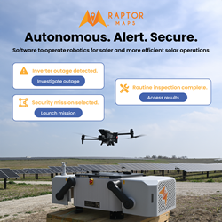
Raptor Robotics is one of our new products that enables the deployment of robotics technology (such as autonomous drones / drone dock technology) on utility-scale solar sites. With our solutions, solar owners and operators can boost their margins by reducing on-site labor requirements, rapidly and proactively identifying risk factors on-site, and using the wealth of data and insights delivered to make strategic decisions on topics such as maintenance planning and equipment procurement.
Raptor Maps is the digital infrastructure to power robotics for solar. The hardware alone is essentially a clean slate that needs to be programmed to create value for each use case. Raptor Robotics provides a library of use cases with standardized flight paths, a data processing engine to transform the data captured into digestible insights, and streamlined software workflows to enable users to track degradation over time, efficiently find issues in the field, and more. In other words, the product allows users to automatically deploy robotics to analyze site performance, on a schedule or based on data-driven triggers like DAS/SCADA alerts.
Our first robotics technology supported is autonomous drones (aka “drone in a box” or “drone dock technology”). Raptor Maps also has the first-mover advantage. We partnered with Enel Green Power to conduct the first autonomous drone inspection of a solar site in North America in early 2023, and have continued to scale up deployments since (source). Our team has a unique level of technical expertise in robotics, solar energy, and drone technology. This allows us to program sophisticated integrations, create missions that are specifically optimized to drive value on solar projects and ensure our customers see results in their project returns.
We partner with hardware providers that have the capability to support solar use cases in order to present a turnkey solution for our customers. Our customers don’t have to work with a variety of stakeholders to implement the solutions, as we manage and operationalize the project in its entirety
Tell us about the R&D behind this product. Who is this product designed for? What problem is it solving?
This product is designed for utility-scale solar site developers, owners, and operators. We think about the problems being solved in 4 main buckets:
-
Reducing the labor requirements associated with data collection to drive consistent, frequent, and cost-efficient analytics.
-
Identifying risk factors proactively to reduce issues impacting performance such as installation errors and misalignment with designs, which create construction delays and create major impacts on early project profitability.
-
Equipment-based underperformance, such as string level outages, cracking and serial defects, tracker misalignment.
-
Managing site security and safety
All of the data and analytics are stored in our platform in a structured data warehouse that serves as a system of record for the health and performance of the asset – without a system of record in place, any intelligence or insight will be lost to time.
Our solution is built on top of our industry-leading digital twin technology, which serves as the blueprint for data collection, as well as the foundation for geo-referenced findings that enable users to trigger, manage, and document any remediation activity required. Given the massive size of solar sites, enabling the user to track their location relative to the findings is crucial to driving actionability. Otherwise, technicians will be searching for a needle in a haystack.
The digital twin serves as the foundation to efficiently enable different types of robotics at scale, and ensure data collected, analyzed, and delivered is meaningful and actionable.
Side note: there is a tax credit incentive!
Asset owners can capitalize on the hardware & software expense for deploying the technology, and US-based asset owners can benefit from investment tax credits (ITC) that can cover 30-40% of the project cost.
Ultimately, our main goal is to accelerate the deployment of solar by boosting project returns, minimizing construction delays, and improving the performance of solar assets. Getting lost production back restores the EBITDA and equity value of solar assets, and ultimately enables more investment into C&I and utility-scale solar.
With the current labor market, gaining transparency into asset performance has become increasingly challenging and expensive; as solar scales rapidly, software needs to pick up the slack and support its ongoing deployment. We have been working with the leading autonomous drone manufacturers in the world since the technology was launched to enable the hardware for solar energy use cases. This includes the Enel case study from the answer above and tons of behind-the-scenes collaboration
Give us an idea on the installation process.
The installation is entirely turnkey and requires just a few hours on-site. We partner with our customers to select the optimal installation location that will provide comprehensive coverage of the site. The hardware requires access to the power and internet, and we work with our customers to ensure those requirements are met reliably and cost-effectively. Our relationships with the hardware manufacturers are at both the corporate and local level, which allows us to procure hardware at priority timelines given limited supply.
How is your company setup to support the users of your products.
Our technical expertise and first-mover advantage means we’ve been able to rapidly incorporate learnings from early deployment of the tech. Our broader platform provides the analytics engine and user interface to translate the data collected from robotics systems into actionable insights for users, which they can act on through our built-in work management and mobile tools or through our API which can fuel their in-house systems.
What feedback have you received from the field? Can you share a use case and the results?
One of our customers is a global IPP that was experiencing >10% of offline site capacity due to equipment anomalies, contributing to over $2M in annualized revenue impact on multiple sites. The customer has deployed our drone-in-a-box solution to proactively identify and reduce underperformance, automatically evaluate production alerts from their SCADA system, identify microcracking throughout the site, and more. The deployment has an estimated ROI of over 9X.
Raptor Maps is the only provider with experience implementing these solutions, and defining the set of solar use cases that will create value for customers.
Comments (0)
This post does not have any comments. Be the first to leave a comment below.
Featured Product